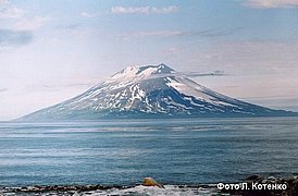
Alaid Volcano
|
||||||||||
| Location | ||||||||||
The volcano-Island, the most northern in the Kurile archipelago, is situated at a distance 30 km north-west from Paramushir and 70 km south-west from Kamchatka.
|
||||||||||
| Form and structure | ||||||||||
The stratovolcano belongs to the Somma-Vesuvius type. The central scoria cone with the height of 250 m is situated inside summit crater. There are 33 lateral cones on the flanks of the volcano. |
||||||||||
| Composition | ||||||||||
| Basalts | ||||||||||
| Age | ||||||||||
| 40,000-50,000 years | ||||||||||
| Links | ||||||||||
| Aviation color code |
GREEN |
| Last VONA/KVERT Releases |
| Hazard synopsis |
Potential hazards are caused by ash plumes, ash falls, lava and pyroclastic flows, and lahars.
Alaid exposes high potential hazard to the aircrafts flying over Kamchatka and the Northern Kuriles because its eruptive clouds can rise to a height of 10-15 km above the crater and extend for hundreds of kilometers (up to 1500 km) and the duration of eruptions can exeed a few months. Ash falls possible at: Severo-Kurilsk (45 km to the south-east from the volcano) Ozernovsky (90 km to the north-east) Ust’-Bolsheretsk (215 km to the north-north-east) Petropavlovsk-Kamchatsky (310 km to the north-east) |
| Monitoring status |
seismic, satellite
|
| Eruptions |
|
2022/9/15 – 2022/12/1
2015/10/1 – 2016/8/18
2012/10/6 – 2012/12/12
1981/4/29
1972/6/18 – 1972/9/11
1933/11/17 – 1934/7
1894
1860/7/7 – 1860/7/9
1854/6/27
1790 – 1793/2
|

