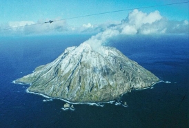
Chirinkotan Volcano
|
||||||||||
| Location | ||||||||||
The Volcano-Island Chirinkotan is located about 29 km west of Ekarma Island
|
||||||||||
| Form and structure | ||||||||||
The edifice of Chirinkotan volcano at sea level has a diameter of 2.5-3 km and an area of 6 square kilometers. Although the top of the volcano rises to 724 m, the actual height of the cone from the bottom of the sea is about 3000 m. At the top of the cone in the explosive crater is a small fresh slag cone with a lava flow. |
||||||||||
| Composition | ||||||||||
| andesites | ||||||||||
| Age | ||||||||||
| Holocen | ||||||||||
| Links | ||||||||||
| Aviation color code |
GREEN |
| Last VONA/KVERT Releases |
| Hazard synopsis |
Ash clouds, ash falls, pyroclastic flows, hot avalanches and lahars are a potential hazard associated with explosive eruptions of this volcano. The volcano poses a potential hazard to international and local airlines passing in the Kuriles region, since the height of its ash emissions can reach 10-15 km above sea level, ash plumes and clouds can drift hundreds of kilometers from the volcano in different directions. In addition, the outflow of lava flows onto the slopes of the volcano and the surrounding area is possibly. |
| Monitoring status |
satellite
|
| Eruptions |
|
2022/3/22
2021/8/8 – 2021/8/23
2017/1/26 – 2017/4/7
2016/11/28
2015/7/21 – 2015/12/10
2013/5/24 – 2014/6/30
2004/7/20
1980/9/28
1979/4/3 – 1979/5/31
~ 1954 – 1955±
~ 1878 – 1889±
|

