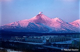
Avachinsky Volcano
|
||||||||||
| Location | ||||||||||
The volcano belongs to the NW-trending chain of 5 volcanoes, which begins from the south the Eastern volcanic zone of Kamchatka. The volcano is located 25-30 km from Petropanlovsk-Kamchatsky and Yelizovo.
|
||||||||||
| Form and structure | ||||||||||
Volcano belongs to the Somma-Vesuvius type. The cone with the crater (diameter of 350 m) filled by eruption 1991 lava is located Inside of Somma (diameter of 4 km) eccentrically to the north. |
||||||||||
| Composition | ||||||||||
| Basalts, andesibasalts, andesites, dacites | ||||||||||
| Age | ||||||||||
| Upper Pleistocene for Pra-Avachinsky; ~ 4000 years for modern cone | ||||||||||
| Links | ||||||||||
| Aviation color code |
GREEN |
| Last VONA/KVERT Releases |
No VONA/KVERT Releases |
| Hazard synopsis |
Potential hazards are caused by ash plumes, ash falls, lava and pyroclastic flows, hot avalanches and lahars. The volcanic dangerous zone threatened by lava and pyroclastic flows, hot avalanches does not exceed 10 km from the volcano. Ash falls and lahars present potential hazard for Petropavlovsk-Kamchatsky, Yelizovo and other settlements situated close to the volcano.
Avachinsky volcano exposes potential hazard to the Kamchatkan airports and aircrafts flying over Kamchatka because its eruptive clouds can rise to a height up to 10-15 km above sea level and extend for hundreds of kilometers. Ash falls possible at: Petropavlovsk-Kamchatsky (27 km to the south-south-west from the volcano) Yelizovo (30 km to west-south-west) Vilyuchinsk (55 km to the south-west) Volcanic hazards map for Avachinsky volcano (Bazanova et al., 2001). |
| Monitoring status |
seismic, web video camera, satellite, visual
|
| Eruptions |
|
2001/10/5
1991/1/13 – 1991/1/30
1945/2/25 – 1945/2/26
1938/3/6 – 1938/3/27
1926/3/27 – 1927/3
1909/8 ±15 days – 1909/8
1901/6/7 – 1901/6/13
1894/10 – 1895/10
1881
1878
1855/5/28 – 1855/5
1827/6/27 – 1827/6/29
1779/6/15 – 1779/6/16
1772
1737/7 ±1 month
|

